 |
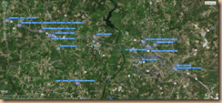
| http://gis.ncdcr.gov/nchhm/ |
It’s amazing how you can grow up in an area but not know a whole lot about the area you live in. Such in the case of my upbringing in rural Anson County, North Carolina. Since my youth I have gained a real appreciation for the past history of the surrounding area.
https://www.flickr.com/photos/riverst/5516897996/
Many of the old cemeteries in Anson and surrounding counties that we knew of as children are now lost forever and/or deliberately destroyed. Cemeteries like the old Scottish cemetery near Morven, NC which is almost lost and only a very few individuals could take you directly to the cemetery. The Gathings Family Cemetery near Jones Creek on what was known as Gathings land in the 1950's where only one stone remains today once held many stones in my youth.
Another cemetery that came to my attention recently is the Old Quaker Cemetery near the Pee Dee River. I had heard of the Quaker cemetery but knew no one who knew exactly where the Old Quaker cemetery was located. I received an E-mail form a genealogical researcher in Charleston, South Carolina a few week ago about this cemetery which led me to research the cemetery and see what I could find about it’s location.
In the land deeds of Anson County, in Deed Book K, page 367 we find the following: 3
Part of a tract of land granted to William Stone as by Patent appears dated April 20th 1745, and conveyed by him to said Benjamin Moorman as by Deed dated the ___day of___17 Beginning at a Sweet Gum in the South Side of the Sandy Branch and runs No. 17 Et. 30 Poles to a Hickory then So. 73 Et. 12 Poles down the Sandy Branch to the first station containing Two (2) acres of Land be the same more or less Including the Burying Ground and Meeting House of the Society of People called Quakers.

From "The History of Anson County" by Mary L. Medley, pages 211-212 - "The Moormans and Clarks settled with other Quaker families on Hitchcock and Solomon Creeks and at one time had a meeting house and cemetery near Hailey's Ferry on the pee Dee Rivers. Early member of the Auld family were also Quakers. 4
This information was carried in a series of "Everett Sketches" in the Rockingham Post Dispatch in 1927.

In the 1960’s Trent Strickland of Hamlet, NC took it upon himself to research and document most what is known today about the Old Quaker Cemetery. The results of his research were printed in an article entitled “The Forgotten Quaker Meeting of Richmond County, N.C.” was published by the Journal of the North Carolina Friends Historical Society; Volume XXIII Spring 2001 Number 1.5 6
https://archive.org/stream/southernfriendse2326nort/southernfriendse2326nort_djvu.txt
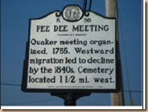
He [Strickland] was also responsible for the erection of a NC Historical Marker K-58 at the intersection of US 1 and Rosalyn Road, Richmond County, NC.7

“Strickland submitted his research to Guilford College to the North Carolina Friends Historical Society in 2000 and it was published as an article in their Spring 2001 journal. He applied to the state historical archives departments for an historical marker and that was approved and erected in summer 2001 on U.S. 1 at Rosalyn Road near Cordova. The N.C. Friends Society also approved funding for a marker at the cemetery, which was dedicated in November 2001.” 8
The old Quaker Cemetery is on private property and no longer accessible. A local historian told me that only 3 tombstones are visible within the cemetery boundaries.
_____________________________
[1] http://gis.ncdcr.gov/nchhm/
[2] https://www.flickr.com/photos/riverst/5516897996/
[3] Anson County North Carolina Deed Book “K” page 367’
[4] Mary L. Medley, History of Anson County, North Carolina: 1750-1976 (Baltimore, Maryland: Clearfield Company, 1976), pages 211-212.
[5] http://archiver.rootsweb.ancestry.com/th/read/CARDEN/2004-11/1099678401
[6] https://archive.org/stream/southernfriendse2326nort/southernfriendse2326nort_djvu.txt
[7] http://www.ncmarkers.com/Markers.aspx?MarkerId=K-58
[8] http://archiver.rootsweb.ancestry.com/th/read/CARDEN/2004-11/1099678401
[9] http://ncgenweb.us/nc/anson/quaker-meetings/
[10] Topographical map courtesy of MT Gathings.
My names Ty Hailey. The Haileys of Hailey's Ferry and the Quaker meetings were my great+ grandparents. I'd like to someday see the exact location of the ferry and the cemetery. If anyone's got anything more accurate than "1.5 miles west of a sign, I'd appreciate if you'd share with me!
ReplyDeleteMy Names Ty Hailey and I'm looking for the Hailey's Ferry, the Hailey's Ferry Settlement, and The "Old Quaker Cemetery". I'm fairly certain I know exactly how to get there but I could use some help. If anyone can help or needs help and/or information too, let's collaborate! Text or call 928-607-1827 or email me, friend.
ReplyDelete